Statistics show that millennials love food, travel, and connecting – and with the PIXEO app, they can achieve photogenic shots even when they are in the midst of unfamiliar locales. Armed with smartphones and cameras, hordes of digital natives search for the holy grail of photos that define them. But oftentimes, get stumped by getting lost or arriving when dusk has fallen; and worse, when the weather conditions deny them pictures worth posting on social media.
With lots of photo-mapping websites, Google Maps, and Apple Maps, why do we even need another app like PIXEO? PIXEO Co-Founder and photographer, Shawn M. Kent said, “I wanted to spend my time shooting, not searching for things to shoot.” This is the very experience he wants every user to have. PIXEO cuts short the tedious search for picture-perfect shots, by providing a mobile map to photo-worthy spots within the targeted vicinity.
No need to spend hours getting there; you can actually have a preview without wasting time, effort, and gasoline. If the site is not to your liking, a simple tap on a pin representing a nearby “photo opp” opens up more choices. You can let your fingers do the trekking from anywhere in the world to save yourself from the disappointment of failed expectations.
Photographic software solutions, built for and by photographers.- PIXEO
There are many categories to choose from and Kent, a military photographer based in Canada and his wife Lisette in cooperation with the app company Mindsea Inc. saw to it that there’s something that matches your interest in the various categories. Set to launch in April 2018, there is more than enough in the 10,000 locations to keep you tapping away.
The husband and wife team together with a team of professional photographers “carefully selected, vetted and verified” each location. Meaning, the app gives you current and exact information – no surprises like a deep cliff, unfinished roads, and other annoying blocks that prevent you from bringing home your share of beautifully captured memories. Finally, you can get reliable directions without surfing the Internet for hours, leafing through travel guides or aimlessly driving around (especially in non-English speaking countries). The app even allows you to “favorite” sites that you may want to revisit when the time is right. It helps you cluster spots you want to visit on your next jaunt or journey. Say goodbye to bulky maps and travel books that are so enhanced that reality dismays.
A tap takes you to a photo, gallery, description, directions, and a map. PIXEL is very collaborative because it encourages other photographers to share their own discoveries, upload photos with full credits, and give valuable feedback. Discover, get inspired, set travel goals, and shoot away on your next unforgettable adventure!
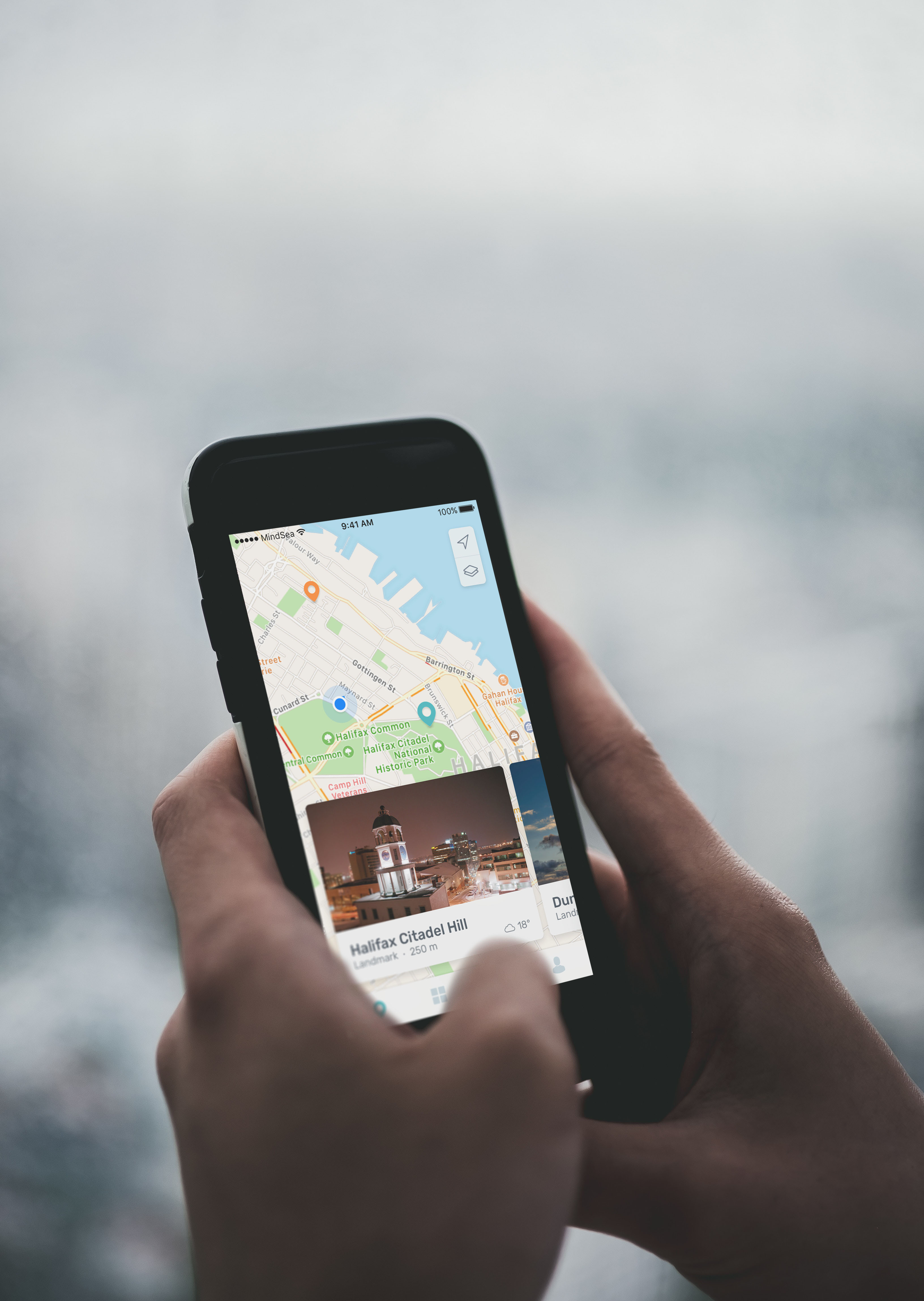
“Tapping on a pin reveals a Hero shot, tells you how far away you are, and even the current weather conditions at the site.”
PIXEO is especially helpful when shooting conditions are challenging or changing. What you see is what you get – no fears that that beautifully decadent relic of a house that speaks to your inner Scarlett O’ Hara (nee Gone With the Wind) has been torn down. And to think that you planned a whole holiday (& plane tickets) after seeing it on a dated YouTube video!
Shawn answered the questions about PIXEO, “The Ultimate Photo Scouting App” candidly and passionately:
1. How different is this from Google and Apple Maps?
PIXEO uses Apple Maps as its underlying mapping software. This is because we didn’t feel it necessary to reinvent the wheel as far as directions and mapping software is concerned. PIXEO uses the maps software and API to “pin” locations based on geo-coordinates. The app itself is genuinely about what happens after you select a pin.
Once a pin is selected the map goes away, and the app truly shows its value. Each location has a page that contains all the information a professional or hobbyist photographer would need to plan a shoot at that location. For each location, there is a sample image of the site (which we call the “Hero Shot”), weather report at the location (vital for capturing sunsets), a detailed description of the site, and feedback from other photographers that have shot at the site. Lastly, each location features a gallery of photos taken by other users.
2. How do you intend to grow your locations?
To begin with, we are using Creative Commons licensed and Public Domain imagery as well as our photos (we’re photographers). We’ve made it very easy for our users to add their own images to each location. Then as more users add to the locations, we will use an algorithm to award the new Hero Shot for the location. I should point out here as well, that it’s essential that photographers get credit for their work, so each image has a watermark that the users set as their image credit to whatever they want. We want to promote the work of our users as much as possible and give them exposure, pardon the pun.
Users can also quickly add new locations to the app. We carefully vet and curate these submissions to make sure the info and coordinates are useful, and that the location is suitable for others to take pictures. Once approved it appears on the map for all users to see and interact with.
We want each location to be kind of like a Pokémon gym for photographers. Photographers can then battle each other to be the one who holds the Hero Shot of each location. For example, if you take a picture of the Eiffel Tower, and it’s better than the one currently being used as the Hero Shot, your pic would replace it and you “own” that location.
In time we want to award PIXEO points to users for owning locations and other contributions to the app. The plan is that users can then exchange those points for app discount codes (you earn your subscription) and eventually gift cards and camera gear.
3. Will there be chat support?
Not yet, we’re pretty small time to start with, and the majority of our resources have gone into building a very high-quality app. As a result, we will have support, but it will be email based to start. The positive spin on that is that you are emailing the developers who made the app and not some call centre. We care about our users and will greatly appreciate them letting us know about any issues with the app so we can fix them.
4. Will there be a desktop and android version? When would the release date be?
We bootstrapped this startup, so all the funding for the app has come out of our pocket. As a result, we don’t have a tonne of investors and VCs giving us money to build the Android and Desktop versions for launch. But, PIXEO was always envisioned as a hybrid app in that it already has some desktop elements (we do admin and curation of the collection from a backend browser interface). As soon as revenue starts to come in, we will begin expanding the desktop version to make it available to the PIXEO user base from their browser. As photographers, we know that we use photo editing tools on our desktop/laptop computers. We need to make it easy to upload your work from there, and we will.
In April 2019 we plan to launch the Android version. We love Android, but the research, the numbers showed that while more people use Android phones, most photogs use iOS devices, so we started there. We are working with a premiere Canadian App Development company, Mindsea, and they do the full spectrum of hybrid development. We look forward to working with them to make PIXEO a go-to tool for amateur and professional photographers alike.
5. Will we see an increase in the number of categories currently available?
It depends on user feedback. At the moment we have 21 categories. It’s important to note that each location can be multiple categories (i.e. Waterfront, Lighthouse, Abandoned). This will allow users to be very specific about the locations they see and like to shoot. As for adding more or less, that will primarily be driven by user feedback.
6. How can users maximize their use of the app?
Interact with the app and contribute to the community. When home, users will discover shooting locations in their own backyard that they never knew were there. As well, when other local users add locations, they will discover new ones. More importantly, their local knowledge will help traveling photogs and is good karma for them when they travel.
This local knowledge is added to the app as feedback for each location. This is freeform commentary so photographers can share tips from their experiences (i.e. how hard it is to access, bring a tripod, great at sunrise, watch out for bears, etc.).
PIXEO also allows photographers to favorite locations. This lets you plan your day of shooting, or when traveling you can plan your vacation. Once you arrive at your destination, no research needed, just step off the plane and go shoot.
One of my favorite things to do is road trip with it. As I drive across the country, I can see all the spots nearby me as I go, and whenever I feel like it, I can stop and shoot a few pics.
Last but not least, it’s incredibly satisfying to find and add an undiscovered location. Being the first to find is very cool, and once we launch we will work to find ways to reward users for doing so.
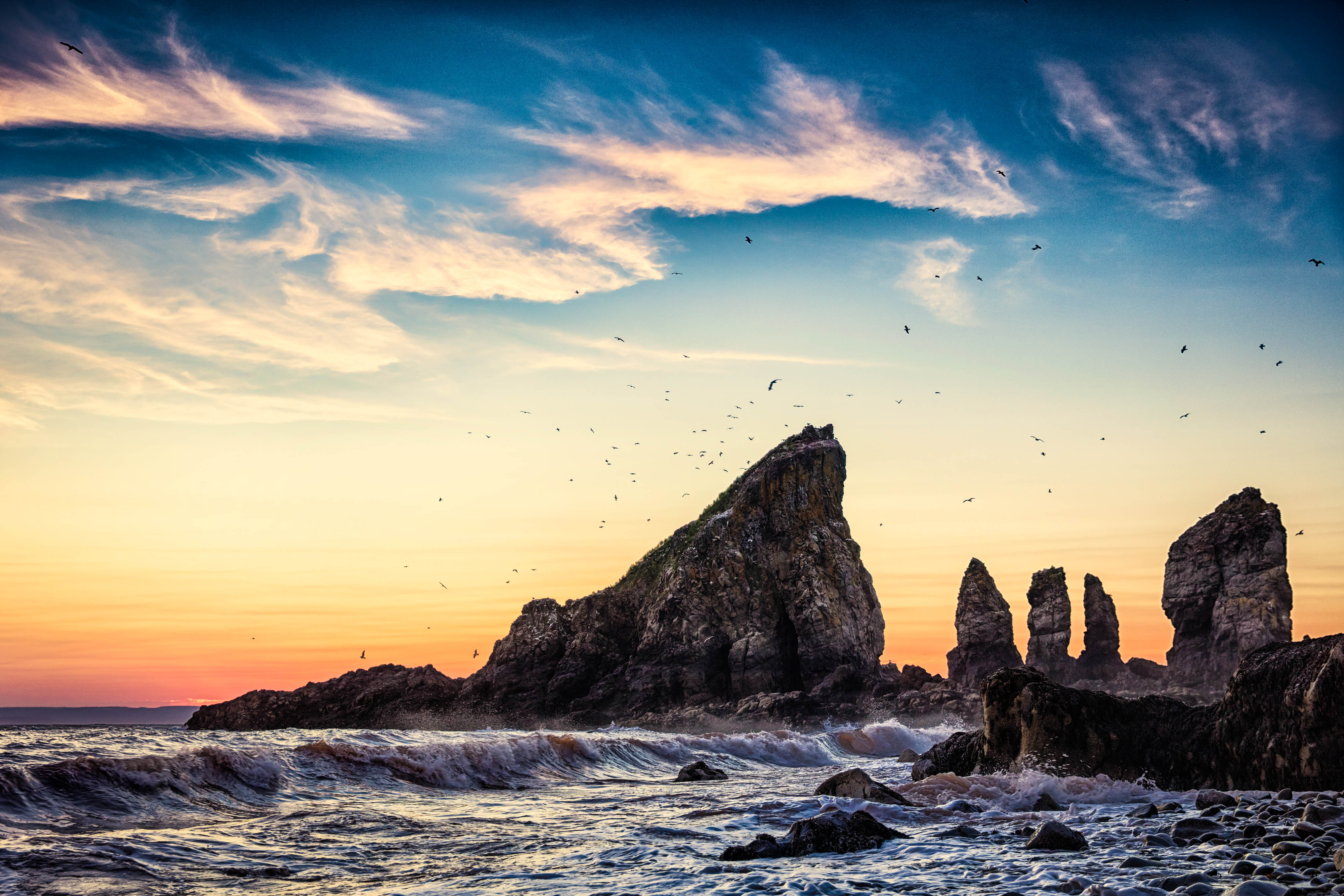
Beautiful geological formations. Site is at the end of 6km hike. Views of the rocks can be seen from the top of steep cliffs (BE CAREFUL!!!) or via the beach. The beach is best accessed by finding the Little Split Cove trailhead at 45.330117, -64.486450. This trail is steep and fairly overgrown, and a rope is in place to aid the climb down to the ebach. The beach itself is rocky and difficult to walk across. Once down at the beach be careful and know the tide schedule. You can and will be trapped if you do not plan ahead.


Photographic software solutions, built for and by photographers.- PIXEO


")

